Inch Castle, County Kildare
From The Illustrated Dublin Journal, Volume 1, Number 30, March 29, 1862
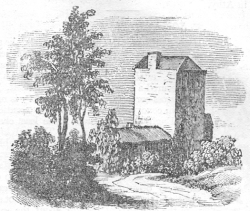 INCH Castle is situated about three miles north-east of Athy, in the
barony of East Narragh and Rheban. It was built by De Vescy, in the
reign of King John, and afterwards enlarged by the sixth Earl of
Kildare, about 1420. There is but one of the towers now remaining, yet,
from the extensive foundations, it must have been a place of
considerable importance. The land in the neighbourhood lies remarkably
flat, with the exception of two ridges that run nearly parallel
northward from the castle, with a marsh lying between them.
INCH Castle is situated about three miles north-east of Athy, in the
barony of East Narragh and Rheban. It was built by De Vescy, in the
reign of King John, and afterwards enlarged by the sixth Earl of
Kildare, about 1420. There is but one of the towers now remaining, yet,
from the extensive foundations, it must have been a place of
considerable importance. The land in the neighbourhood lies remarkably
flat, with the exception of two ridges that run nearly parallel
northward from the castle, with a marsh lying between them.
It was on those heights the armies of Ormond and Mountgarrett, in 1642, marched in sight of each other the evening previous to the battle of Kilrush; that of Ormond on the high grounds of Ardscull, Fontstown, and Kilrush; whilst the forces under Mountgarrett, and attended by the Lords Dunboyne and Ikerrin, Roger Moore, Hugh Byrne, and other leaders of Leinster, proceeded in the same direction, along the heights of Birtown, Ballyndrum, Glassealy, and Narraghmore. Mountgarrett having the advantage in numbers, and anxious for battle, out-marched Ormond's forces, and posted himself on Bullhill and Kilrush, completely intercepting Ormond's further progress to Dublin; a general engagement became unavoidable. The left wing of the Irish was broken by the first charge; the right, animated by their leaders, maintained the contest for some time, but eventually fell back on a neighbouring eminence, since called Battlemouut; where, after a determined resistance, they at length broke and fled.
The country for miles around Inch Castle has many historical connexions; to the east may be seen the much spoken of Rath of Mullaghmast, the ancient Carmen, or the enclosed place, which was the Naasteighan, where the states of the southern parts of Leinster met. It is situated on a high and gently sloping hill, and near it are sixteen little conical mounts, on which, it is supposed, the chiefs sat in council. Carmen was anathematized in the sixth century, and the place of assemblage of the chiefs was then removed to the present Naas, one of the shire towns of the county. It takes its present name, Mullaghmast, or Mallach Mastean, (the moat of decapitation) from the perfidy of gome adventurers in the sixteenth century, who having overrun part of the neighbouring country, were resisted by the Irish chieftains who had properties on the Leix (Queen's county) side of the river Barrow. However, in order to have a final settlement of their differences, it was proposed by the adventurers, that a conference should be held at Carmen, which was agreed to; and on New Year's day, 1577, the chiefs of the Barrow side repaired to the place, where they were treacherously made prisoners and beheaded.
A little to the north of the castle is also to be seen the Moat of Ardscull, Ascull, or Arstoll, anciently Rath-ais-Ceal, corruptly Rath-scull. In 1315, the Scots, under Robert Bruce, gained a battle here, and plundered the neighbourhood. The rath where the battle was fought, and commands a great extent of country. Hammond le Crose, Sir William Prendergast, and John, Lord de Bonneville, on the part of the Irish; and Fergus Andressan and Sir Walter Murray, of the Scottish parly, were slain in this battle, and buried in Athy.