Fair Head, County Antrim - Irish Pictures (1888)
From Irish Pictures Drawn with Pen and Pencil(1888) by Richard Lovett
Chapter X: The Giant's Causeway and the Mourne Mountains … concluded
« Previous Page | Start of Chapter | Book Contents | Index »
Benmore, or Fair Head, is fitly described as the climax of the Antrim coast. It rises 639 feet above the sea, and half of this is taken up by huge columns of greenstone 30 feet wide. Through an enormous chasm in the cliff a path runs, by which a good view of the face of the headland is obtained. It may be explored without danger, if reasonable care is exercised. Across the top of the chasm, which is called the Grey Man's Path, a huge pillar has fallen, forming a natural bridge. From the top of the headland is a magnificent view extending to the Scotch coast, and over Rathlin Island, and away beyond the Causeway to the distant shores of Inishowen.
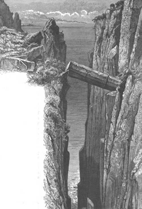
Grey Man's Path
Leaving Ballycastle, the road runs through pleasant country by way of Cushendun and Cushendall to the coast, which it then skirts closely all the way to Larne. It first passes around Red Bay and Garron Point. Here is Garron Tower, built by the late Frances Ann, Marchioness of Londonderry, and bequeathed by her to a younger brother of the present marquis. From Garron Point to Glenarm a constant succession of very charming views are enjoyed, the sea and coast scenery being every here and there varied by beautiful inland peeps.
Larne is well-situated, and has a good harbour. Hence the return journey to Belfast is made by way of Carrickfergus and White Abbey. At the former there are some very interesting remains, the chief being the old Anglo-Norman castle; it dates from 1178, and occupies a strong position on a rock which overlooks Belfast Lough.
One other beautiful district of Ireland lies within easy reach of Belfast, viz., Rostrevor and the Mourne Mountains. This district lies between Belfast and Carlingford Loughs. The latter is very beautiful, the shores being well-wooded, and the hills rising steeply from the water. The town of Carlingford lies on the southern shore, and, like Carrickfergus, contains an ancient Anglo-Norman castle, but not in such a good state of preservation. On the north shore is Rostrevor, a noted and very lovely little watering place. There are not wanting those who put it at the head of the watering places of the United Kingdom. The little town stands between two rivers, and behind it Rostrevor Mountain rises up nearly 1,600 feet. The railroad ends at Warrenpoint, four miles from Rostrevor, and a splendid drive can be taken around the coast to Newcastle, where the railroad from Downpatrick stops. By this route Kilkeel is passed. Newcastle is a formidable rival to Rostrevor, and is the best point from whence to visit Slieve Donard, the highest point of the Mourne Mountains. It attains a height of 2,796 feet, and affords a view of great extent, not only over the whole group of mountains of which it forms a part, but inland, over Newry to Slieve Gullion; to the north over the fertile County Down; to the south as far as Howth; and over the Irish Sea to the hills of the Isle of Man. On the return journey to Belfast, Downpatrick should by all means be visited. Here, according to the Tripartite Life, St. Patrick was buried, and tradition, with less probability, asserts that St. Columba and St. Brigid were also interred here. St. Patrick founded a monastery at Downpatrick very early in his Irish labours. The present cathedral dates only from 1790. A very fine rath exists in the town, and a Druidic Ring, only three miles distant. On the road to this are the Wells of Struel, a famous place of pilgrimage.
Farewell, Yer Honour!
THE END
« Previous Page | Start of Chapter | Book Contents | Index »