Gweedore and Mount Errigal - Irish Pictures (1888)
From Irish Pictures Drawn with Pen and Pencil (1888) by Richard Lovett
Chapter VIII: The Donegal Higlands … continued
« Previous Page | Start of Chapter | Book Contents | Next Page »
If the coast route is not followed in the journey from Carrick to Ardara, and the beaten track is chosen, a very fine stretch of bleak moorland country is traversed. The road gradually rises, the country getting wilder and wilder, until at an elevation of about 1,000 feet the highest point is reached, and immediately below is the Pass of Glengesh, while spread out before one is a fine view of the central Donegal Mountains. The crest once surmounted, the road descends rapidly by abrupt turns into the glen, the hills towering aloft on either hand. The scenery gets less and less wild as the road descends, and the valley towards the mouth becomes smiling and green and fertile. A short run brings the car into Ardara, and ascending the steep hillside on which the main street of this little town stands the road to Glenties is reached. An hour's ride along the slope of a pleasant valley brings one to the town, which owes its importance mainly to the fact that it is a convenient place for changing horses. A handsome workhouse is the great architectural feature of the place; several mountain glens and the roads passing through them converge upon it; but there is little connected with it to tempt the wayfarer into any lengthy stay.
Between Glenties and Gweedore a long stretch of extremely wild and barren country intervenes, so wild and bare as to be hardly rivalled in the United Kingdom. The absence of wood and foliage intensifies the impression of barrenness. What picturesque effect it possesses is due mainly to the hill contours, and to the shades of moorland browns, varied with occasional oases of living green, often entirely due to large patches of Osmunda regalis, the royal, flowering fern. Seen, as not unfrequently, beneath a grey sky and with a keen east wind blowing, the visitor on the jaunting car is apt to think that Irish miles in these parts are abnormally long, and that in the course of his wanderings over the face of the earth he has never traversed a more hopeless soil or a more thinly populated country.
The first point of real beauty in the journey is when the road touches the valley of the Gweebarra, a fine salmon stream, emptying into Gweebarra Bay. The road for some miles skirts the southern bank, which is bleak and barren; but on the opposite side the valley rolls away in gentle slopes, dotted plentifully with whitewashed cabins, and cultivated fields, supporting evidently a considerable agricultural population. At Doochary Bridge the road crosses the river, and immediately climbs by zig-zags the steep northern bank. From the top some very fine views are obtained; and then for seven or eight miles the road traverses wild moors.
Dungloe is a village nestling on the slope of a hill, but neither beautiful for situation nor particularly attractive in itself. The road to Gweedore, some thirteen miles, is very pleasant, and affords considerable variety of scenery, but is not comparable to several that Donegal can show. By far the finest drive from Glenties to Gweedore is to go by way of Doochary Bridge and Glen Veagh, a longer but a much wilder route. But the best way to appreciate the Errigal district is to make the Gweedore Hotel a centre and explore the country by daily excursions.
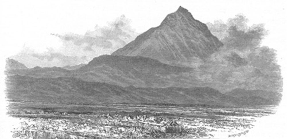
Mount Errigal
Gweedore is situated upon the Clady, a pretty stream forming the outlet of a chain of loughs. The most conspicuous object in the landscape is Mount Errigal, only a few miles distant, and very accessible. It presents widely different appearances from different points of view; from Gweedore itself looking like a dome; from other directions exhibiting the sharp ridge and bold peak shown in our engraving. Scattered over the slopes are immense quantities of a loose shale of a pure white colour, which, seen from a distance, have almost the effect of snow. On the south-eastern side the peak slopes down by a sharp ridge, which affords a capital path up to the very summit. The height is 2,460 feet, and any fair walker can easily manage the ascent. The writer first saw it on a bright sunny afternoon in June, towards the close of a long drive from Creeslough. It looked so inviting and so easy to climb that the temptation was irresistible. Instructing the car-driver to wait, he started, and at once met the chief difficulties of the expedition. The ground at the foot of the mountain is boggy, and some care is needed in crossing the half mile or so of nearly level ground. But once on the ridge the rest was easy. The view from the summit was superb.
The complete isolation of the peak, the extreme abruptness with which the mountain slopes away in all directions but one, and the grandeur of the surrounding peaks, render the enjoyment of being actually on the summit exceedingly keen and invigorating. The eye is bewildered at first by the vast extent and variety of the landscape unfolded. Looking to the north and east, the mountain seems to break away almost from beneath one's feet, and although it is at least a mile from the base, Altan Lough looks so near that you think the stone in your hand could be easily tossed into it. Beyond the lough the steep cliffs of Aghla More rise up abruptly for nearly 2,000 feet, and beyond them towers the huge mass of Muckish, the mountain that dominates all North-western Donegal. Far away in the distance, Mulroy Bay, Lough Swilly, and the blue ocean are in full view. Immediately to the north and east, Dunfanaghy, Horn Head and Tory Island seem to lie at one's feet. To the south the fine ranges of the Derryveagh Mountains, the Poisoned Glen, and Slieve Snaght, separated from the observer only by the narrow valley in which are nestled Loughs Dunlewy and Nacung, stretch out to the right and left, while beyond them is an ever-widening circle of mountains, bounded on the west by the restless Atlantic, and stretching away to the south and east as far as the eye can reach. No finer view exists in Ireland than the wondrous panorama stretched out before the observer who sits upon the topmost peak of Errigal, and no better position for rapidly acquiring the topography of Donegal could possibly be desired. Although the side of the mountain facing Dunlewy looks dangerously steep when viewed from below, the writer had no difficulty in descending on that side, and rejoined his car after an absence of two hours.
No visitor to Gweedore should miss Glenveagh, the most famous of Donegal valleys. The way to see it in all respects to the best advantage is to take a car from Gweedore, drive past Lough Nacung, and the southern side of Errigal, through what is known as the valley of the Calabber. From the water-shed separating the valleys of the Owenbeg and the Calabber a grand mountain view is obtained. On the left Errigal, Aghla More, Aghla Beg, and Muckish lift up their mighty masses; on the right stand the peak and slopes of Mount Dooish, and in front a fine distant view is obtained over Creeslough. Some miles beyond this crest the road turns to the right, crosses the Glenveagh river and runs for some miles along the southern shore of Lough Veagh. Near the further end of the lough stands a modern building, a blot rather than an adornment to the landscape, known as the Castle. Beyond the Castle the road winds along at the foot of a well-wooded slope. The opposite bank of both lough and glen are much wilder. The mountains descend for a thousand feet nearly sheer to the water, or to the level of the valley. At one part a beautiful cascade runs like a snow-white thread down the face of the cliff. Ascending still further the scene grows wilder and wilder. Here the car should be left to return to Dunlewy, and the rest of the trip made on foot. A magnificent walk enables the pedestrian to hit the head of the Poisoned Glen, a wild and rugged valley directly opposite to Mount Errigal, and to descend through it rejoining the Gweedore Road at Dunlewy. By this route a constant succession of most beautiful mountain views is enjoyed.
« Previous Page | Start of Chapter | Book Contents | Next Page »